


Flora, IL
Advertisement
Flora, IL Map
Flora is a US city in Boone County in the state of Illinois. Located at the longitude and latitude of -88.475891, 38.668821 and situated at an elevation of 147 meters. In the 2010 United States Census, Flora, IL had a population of 4,803 people. Flora is in the Central Standard Time timezone at Coordinated Universal Time (UTC) -6. Find directions to Flora, IL, browse local businesses, landmarks, get current traffic estimates, road conditions, and more.
Flora, located in the heart of Illinois, offers a quaint and welcoming atmosphere that embodies the essence of small-town America. Known for its rich history and charming downtown area, Flora provides a delightful blend of old-world charm and modern conveniences. Visitors can explore a variety of local shops, dine in cozy eateries, and enjoy the serene parks that dot the landscape. The city serves as a gateway to the natural beauty of Southern Illinois, with easy access to outdoor activities such as hiking and fishing in the nearby state parks. Flora's friendly community and relaxed pace make it an ideal destination for those seeking a peaceful retreat.
Nearby cities include: Harter, IL, Stanford, IL, Keith, IL, Zif, IL, Garden Hill, IL, Indian Prairie, IL, Pixley, IL, Orchard, IL, Blair, IL, Elm River, IL.
Places in Flora


Can't-miss activities
Culture, natural beauty, and plain old fun.


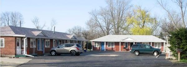
Places to stay
Hang your (vacation) hat in a place that’s just your style.


Advertisement